What can drone mapping services do to help modern-day farmers? Contemporary farming emphasizes data, precision techniques, and innovative practices. Farmers eyeing cutting-edge technologies to confront age-old challenges and apply new technology to enhance productivity. Drones are one of the most revolutionary tools at this change.
Drones enhance precision, accuracy, and profitability throughout the process, from planting to harvesting. Through Drone Services for Agricultural purposes, farmers can obtain real-time aerial data, which would take a couple of days or maybe weeks. The tools now also allow for decisions based on modern thinking that would have been unthinkable a decade ago.
Let us discuss the impact of aerial innovations like drones on agriculture to enable better data collection, crop monitoring, and soil analysis.
The Rise of Precision Agriculture
Precision agriculture recognizes a farming approach that employs technology to monitor, quantify, and address variations in crop conditions. Rather than treating the whole field uniformly, farmers treat their fields by zones and respond to the specific needs.
What makes this possible? Data. Drones are the fastest and most cost-effective way to get actionable agricultural data.
Why Aerial Innovations Matter
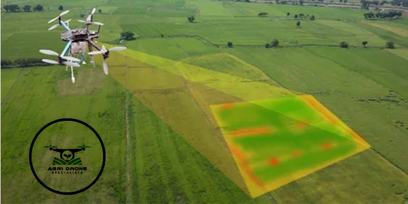
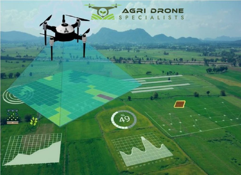
Agriculture is always at the mercy of nature. Harvesting depends heavily on weather, pests, disease, and soil quality. Drone technology gives farmers a bird’s eye view of their lands- the earlier they identify problems, the faster they make data-supported decisions.
Some aerial innovations entail:
• Field configuration and 3D terrain modelling
• Multispectral imaging for crop health analysis
• Monitor plant growth and stress
• Irrigation and fertilization management
• Early detection of diseases or infestations
Let’s now examine a few ways Drone Services for Agricultural use are helping to change farming.
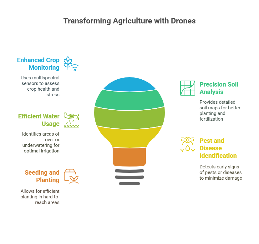
1. Enhanced Crop Monitoring
Monitoring crop health across hundreds or thousands of acres is exhausting and time-consuming. Traditional methods involve foot inspection or satellite images, having substantial drawbacks.
The multispectral sensor-equipped drones can survey vast areas faster while gathering information on plant health, water stress, and nutrient deficiencies. The timely interventions can save crops and increase output.
They do not act on visible symptoms. Instead, they act on information that is invisible to the naked eye.
2. Precision Soil Analysis and Mapping
Successful crop cultivation begins with healthy soil. With the emergence of drones, soil analysis and planning have become easier than ever. The Drone Mapping Services provide a detailed 3D map of a field, showing elevation changes, erosion-prone zones, and other key factors related to irrigation and planting patterns.
Several drones carry sensors to help measure soil moisture and composition- so planting times and fertilization levels are adjusted accordingly, reducing wastage and increasing output.
3. Field Mapping and Surveying Made Easy
Before planting seeds, farmers require a data set describing the field. Surveying the field through traditional methods is very time-consuming and expensive. This one can be done faster and at cheap prices with drones.
With high-res cameras on board tracking irregular flight paths enabled by GPS, drones generate orthomosaic maps showing exact field dimensions, topography, and crop distribution. The information is then used for irrigation and drainage planning, planting zones, and fencing.
4. More Efficient Water Usage and Irrigation
Water is precious in drought-prone areas. You can identify areas where crops are either overwatered or underwatered via the information collected by drones. Multispectral imaging detects issues before water stress becomes visible on plants, ensuring optimal irrigation practices.
The practices combined with automatic irrigation systems can make farms more environmentally responsible and sustainable.
5. Pest and Plant Disease Identification
The most effective way to deal with a pest outbreak or disease is early detection. Drones can help notice differences in colour or changes in crop patterns that may indicate pest infestation or pathogens. Farmers can recognize the issue early and apply pesticides or fungicides only where necessary, which helps to conserve chemicals and protect the environment by using lower levels of toxic products. Additionally, the earlier the detection ensures less overall crop damage to continue protecting profit.
6. Seeding or Planting with Drones
Drone seeding is highly effective for reforestation and cover cropping, which saves time and allows planting in areas challenging to access with tractors or on foot.
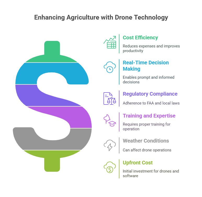
Cost-Efficiency Factor
Investing in drone services can feel like an expense upfront. But it gives you information about the crop, saving subsequent dollars and improving productivity. Using drone technology for agricultural purposes is worth it. Drones allow farmers to eliminate manual labour and waste of other farming resources and will help farmers grow healthy crops that yield more.
Studies show that farms using Drone Services for Agricultural applications can help gain up to 30% more efficiency in crop management, and input costs can be reduced by 25% or more.
Real-Time Decision Making
Real-time aerial surveillance allows farmers to make informed decisions promptly, whether related to a sudden pest outbreak or redirecting water to an area of the field. Data collected by drone can be imported into farm management software, creating a streamlined digital workflow for better planning, budgeting, and contingency reporting.
Challenges and Considerations
Though the benefits are evident, there are a few challenges you can face for drone adoption in agriculture:
• Regulatory Compliance: Farmers can follow FAA regulations and check local laws for drone services.
• Training and Expertise: For best results, proper training is required to operate drones and understand and interpret aerial data.
• Weather conditions can affect drone operations for agricultural purposes.
• Upfront Cost: A quality drone and software will require an upfront investment.
These barriers are beginning to decrease due to improved training programs, lower prices on drones, and the use of services by specialists.
Conclusion: Capitalizing on the Sky for Improved Harvests
The future of farming will be digital, data-driven, and aerial. Using Drone Mapping Services for Agriculture, growers have advanced from simply responding to issues to predicting and preventing them. With these technologies, growers can achieve precise control over their land management, lower costs, and increase sustainability.
The future of farming is digital, data-driven, and aerial. By utilizing drone services for agriculture within their operations, growers are no longer just responding to issues but are proactively predicting and preventing them. These technologies enable growers to get precise control over land management, reduce costs, and increase sustainability. Drones are invaluable in modern agriculture, whether recognizing stressed crops before they express symptoms, mapping irrigation zones at an accurate water concentration, or surveying hundreds of acres in a single afternoon.
At Agri Drone Specialists, we help farmers unlock the true potential of drone technology. Our tailored Drone Mapping Services provide actionable insights that will cut costs and make your farm more efficient. Our team combines technical expertise with extensive agricultural knowledge to provide high-resolution aerial data, sophisticated crop analytics, and support. Whether you want to start with drone monitoring or to scale your precision agriculture practices, Agri Drone Specialists is your trusted and reliable partner in the field and the sky. Contact us today to see how we can help your farm grow smarter- one flight at a time.